Drawing on fine-scale surface dynamics observed during a large drifter experiment in the Western Mediterranean Sea, a recent study assessed the quality of SWOT sea level measurements acquired during the 1-day repeat orbit phase. This work establishes a benchmark for extending SWOT sea level assessments to the global ocean.
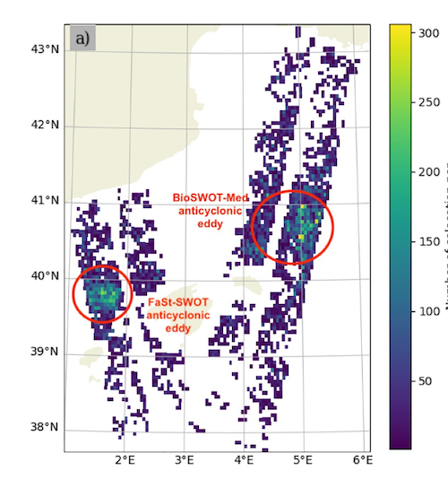
Spatial distribution of Surface Water and Ocean Topography‐drifter colocations in the Western Mediterranean Sea during the fast sampling period. Credits: Demol et al. 2026
The SWOT satellite captures sea level data at an unprecedented resolution making it possible to study fine-scale ocean processes and their role in the climate system. However, estimating the direction and intensity of fine-scale currents from SWOT measurements remains challenging due to various sources of error, including instrumental errors of SWOT’s KaRin altimeter and a still incomplete knowledge about ocean surface dynamics.
To overcome these challenges, the paper “Large Drifter Experiment in the Western Mediterranean Sea Reveals Dynamical Versus Noise Contributions in SWOT-KaRIn Sea Level” published on Geophysical Research Letters applied a novel strategy using 137 surface drifter trajectories and momentum conservation covariances analysis. This approach made it possible to assess the quality of SWOT sea level data gathered during the 1-day repeat orbit in spring 2023 in the Northwestern Mediterranean Sea.
The in situ drifter data used for the analysis were collected during three SWOT AdAC field campaigns (C-SWOT-2023, BioSWOT-Med, and FaSt-SWOT) that occurred under SWOT passes 3 and 16.
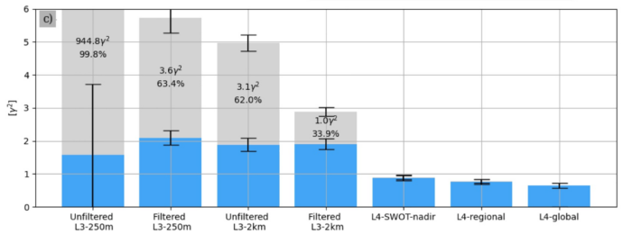
Balanced contribution (blue) and residual contribution (gray) for the different altimetric products and filtering levels. Note that the residual contribution of the unfiltered L3‐250m product is truncated because it is nearly 300 times larger than other residuals. Credits: Demol et al. 2026
Removing noise while preserving the oceanic signals of interest
Currently, various processing and filtering techniques are applied to mitigate SWOT instrumental and geophysical errors but their performance still needs to be carefully assessed to make sure that they do not remove the fine-scale dynamical signals. “In particular, we must determine whether these processing steps successfully remove noise while preserving the oceanic signals of interest. Excessive filtering may inadvertently suppress small-scale dynamical features that SWOT is specifically designed to observe“ says Margot Demol, post-doctoral researcher at the Laboratory for Ocean Physics and Satellite remote sensing, in Plouzané, France, and corresponding author of the study.
Even if SWOT sea level measurements were completely free of noise, still a fundamental challenge would remain before SWOT data can be used to confidently infer fine-scale ocean dynamics. “Surface currents are commonly derived from sea level using the geostrophic balance, which assumes that the dynamics are primarily governed by a balance between the horizontal pressure gradient force and the Coriolis force. This approximation is generally valid at large spatial scales and has been successfully used with conventional altimetry” explains Demol. “However, SWOT resolves much smaller spatial scales, where ageostrophic processes become increasingly important. At these scales, the geostrophic assumption may no longer provide an accurate estimate of surface currents. We currently lack a clear understanding of the resulting errors and of which additional dynamical processes should be included to improve current estimates” says Demol.
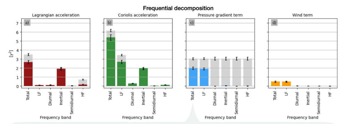
Balanced and residual contributions (colored and gray bars, respectively) for the reconstruction using the filtered L3‐2km and drifter/wind data filtered in different frequency bands. Credits: Demol et al. 2026
A strategy to assess SWOT sea level measurements relying on reconstructions of the ocean surface dynamical balance equation and a covariances analysis
A first approach to assess surface currents derived from SWOT measurements consists of comparing them with velocity estimates obtained from drifters. This approach, however, has a major limitation because it combines errors arising from measurement noise in SWOT sea level observations with discrepancies due to ageostrophic motions.
To disentangle these two sources of error, researchers developed an alternative approach. “We reconstructed the surface momentum conservation equation, including ageostrophic terms and using colocated observations from SWOT sea level measurements, drifter trajectories, and a wind reanalysis product” says Demol. By analyzing the covariances of the different terms in this equation, researchers were able to quantify the proportion of useful dynamical signal (defined as variability dynamically correlated with other terms of the momentum balance) and distinguish it from noise.
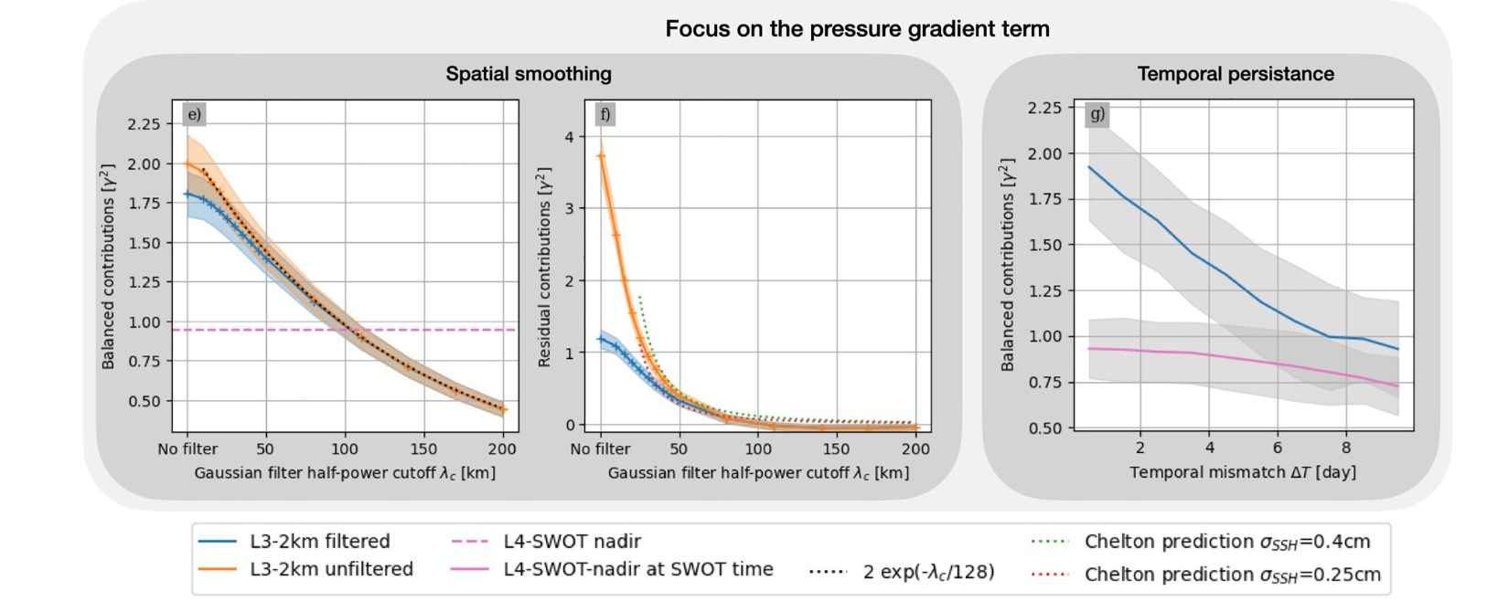
Dependency of pressure gradient term (e) balanced and (f) residual contributions on the Gaussian filter half‐power cut off wavelength λc. (g) Dependency of the pressure gradient balanced contribution on the time difference for L3‐2km product and L4‐SWOT‐nadir product but interpolated at the Surface Water and Ocean Topography time. Credits: Demol et al. 2026
Fine-scale processes are best studied with the filtered SWOT product at 2 km grid
Different SWOT products are being developed that provide sea surface height at different spatial resolutions. The study compared the amount of dynamical signal and noise across two of them, the L3-250m product and the L3-2km, providing respectively sea surface height on a 250 m × 250 m grid and on a 2 km × 2 km resolution. The comparison found that the two products show similar amounts of dynamically useful signals but differ in their noise levels, with the 2km filtered product best suited for fine-scale studies because of lower noise levels. However, even for this product, the residual noise remained about a third of total variance highlighting the need for further smoothing. How to carry out this smoothing remains an ongoing open question for the scientific community.
The study also permitted to assess that the added value of current SWOT products in assessing dynamical sea level (DSL) information concerns motions faster than 10 days, an aspect that is of particular importance for users of SWOT data in the science phase, with 21-day revisit period.
For the time period and the geographical area considered in the study, indeed, when the temporal lag is bigger than 10 days the L3-250m and L3-2km products do not provide more meaningful DSL than conventional gridded nadir-only products (L4). Although these conventional products retain only half the useful signal of L3 products, they are in fact nearly noise-free thanks to the L4 interpolation processing and thus may be more reliable for large-scale applications.
A benchmark for extending SWOT sea level assessments globally
Results from the study show that the1-day orbit provided dense enough observations to capture the bulk of the variability in the Northwestern Mediterranean Sea and that drifters are extremely valuable for the evaluation of SWOT sea level performance. The methods used in the paper provide a benchmark for extending SWOT swath sea level assessments globally.
Citation: Demol, M., Ponte, A. L., Garreau, P., Bellacicco, M., Berta, M., Centurioni, L. R., et al. (2026). Large drifter experiment in the Western Mediterranean Sea reveals dynamical versus noise contributions in SWOT‐KaRIn sea level. Geophysical Research Letters, 53,e2025GL121425. https://doi.org/10.1029/2025GL121425
Contact: Margot Demol margotdemol.oceano@proton.me
Visit the campaigns pages: C-SWOT-2023, BioSWOT-Med, FaSt-SWOT