Using data collected with the SWOT satellite, a study published on Geophysical Research Letters describes the spatial structure of low amplitude oscillations, known as seiches, in the lagoons of several atolls in the French Polynesia. This ability to detect seiche-like structures in small bodies of water (less than 80 km in length) is unprecedented in satellite altimetry and opens up new avenues of research into these events and their contribution to erosion and flooding in remote locations.
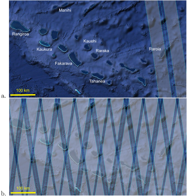
The paper “SWOT Sheds Light on Seiche Oscillations Within Atoll Islands” published on Geophysical Research Letters shows the capability of SWOT satellite to capture two-dimensional sea surface undulations of low amplitude (on the order of a few centimeters) in small bodies of water such as the lagoons of several atolls in French Polynesia. The paper first compared data collected by SWOT during the Cal/Val phase with in situ measurements in the Raroia lagoon to assess SWOT capabilities to observe seiches. Then, it used SWOT data collected during the Science phase and idealized modeling to extend the study of these low amplitude oscillations of sea surface height to a total of 7 atolls.
During the Cal/Val phase, one of SWOT swath was located over the Raroia lagoon (15km x 40km in size), which it overpassed 97 times. The Raroia lagoon was instrumented with 9 pressure sensors that retrieved the water height within the lagoon and outside the barrier reef. The data from SWOT overpasses during the Cal/Val phase were used to create ad hoc-estimates of Sea Surface Height (SSH) Anomaly in the lagoon using the 2‐km and 250‐m KaRIn Low Rate SWOT products. This constructed SSH anomaly was compared to the relative water level that was reconstructed from the 9 pressure sensors, showing impressive reliability of SSH anomalies estimated by SWOT.
Indeed, the root mean square value of the differences between SWOT and the in situ sensors is of the order of 2–3 cm within the Raroia lagoon, both for the 2‐km and 250‐m KaRIn Low Rate SWOT products, supporting SWOT’s capability to resolve centimeter-scale water level variability in lagoons.
These results are impressive. “First, of course, because of the amazing resolution (here 250m, but the HR mask will soon be activated above these islands, which should yield an improved observation)! Second, because at such scale, in situ measurements can provide useful information on the period of these waves, but fail to capture the spatial structure of these modes, which vary over distances in excess of 10km. Only satellite observations can provide such a spatial description” says Ludivine Oruba, researcher at the Laboratoire Atmosphères, Observations Spatiales (LATMOS).
SWOT observation of seiches in French Polynesia lagoons
Once the effectiveness of SWOT data in revealing small undulations of sea surface height was established, the work was extended to include a total of 7 atolls in French Polynesia using data from 29 SWOT overpasses from the Science Phase and implementing for each of them a shallow water numerical model formulated as an eigenvalue problem.
“The horizontal extent of these modes (a few tens of kilometers) being large compared with the water depth (a few tens of meters), a shallow water formalism can be used to derive a mathematical model. The eigenmodes of this model were shown to match SWOT observations, and the eigenvalues (corresponding to the periods of the modes) were confirmed by in situ observations. The eigenvalue model therefore complements spatial and in situ observations” says Emmanuel Dormy, researcher at the Département de Mathématiques et Applications, Ecole Normale Supérieure.
Seiche modes (images below) correspond to natural oscillations of the water surface at the lagoon scale. They oscillate -much like the membrane of a drum- with a number of positive and negative SSH anomalies, alternating in time and separated by node lines (where the water is at rest).
The comparison of the theoretical (expected) structures from the eigenvalue model with seiche-like structures derived from SWOT measurements shows how impressive the SWOT measurements are.
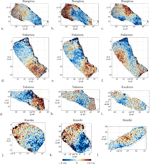
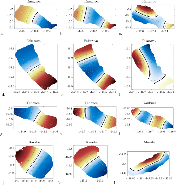
Sea Surface height anomaly reconstructed from SWOT measurements in the French Polynesia lagoons (left). Theoretical (expected) structure of seiche-like structures from the eigenvalue model (right). Credits: Rebouillat et al. 2026 (Fig 2 and 3).
Relevance to society
SWOT ability to detect seiche-like structures in small bodies of water (less than 80km, and only 15km x 40km in size as in the case of the Raroia lagoon) is unprecedented in satellite altimetry and opens up new avenues of research into these events and their contribution to erosion and flooding in remote locations where deployment of in situ measuring instruments is challenging.
“These large-scale, but small amplitude, oscillations can become much larger in amplitude when forced by extreme storms. They then result in recurrent flooding (at the period of oscillation of the mode) -as reported by inhabitants- and also in significant sediment transport and erosion. In the context of climate change, with increasing intensity of extreme events and rising mean sea levels, seiches events are likely to become more frequent and more devastating. The SWOT mission will therefore provide precious insights into the geometry of these seiches” says Emmanuel Dormy.
The work was supported by TOSCA/CNES Maeva Project and Institut des Mathématiques pour la Planète Terre.
Citation: Rebouillat, E., Oruba, L., Hopuare, M., Planes, S. and Dormy, E., 2026. SWOT sheds light on seiche oscillations within atoll islands. Geophysical Research Letters, 53(4), p.e2025GL119801. https://doi.org/10.1029/2025GL119801
Contact: Ludivine Oruba (ludivine.oruba@latmos.ipsl.fr) and Emmanuel Dormy (emmanuel.dormy@ens.fr)
Other relevant papers on SWOT capabilities to detect seiche-like structures:
Monahan, T., Tang, T., Roberts, S., & Adcock, T. A. A. (2025). Observations of the seiche that shook the world. Nature Communications, 16(1), 4777. https://doi.org/10.1038/s41467‐025‐59851‐7
